
Geographic information science (GIS) is a relatively new field that uses computer technology to link maps to digital data. Resource managers and urban planners rely on the expertise of GIS technicians when they are making critical decisions about asset management, environmental assessment, development, and harvest. GIS skills are applicable in any organization that maintains assets in the environment. Graduates work with mines and resources, utility companies, First Nations, urban and rural municipalities, and health care agencies, to maintain information with geospatial reference.
Start date
August 2026 (in person)
August 2026 (online)
Length
32 weeks
Location(s)
Prince AlbertOnline/Distance options availableLength and location notes
Some programs offered online or otherwise by distance (i.e., correspondence) include on-site labs, clinicals, practicums or work experiences. They may be offered course-by-course or full-time, or both, and deliveries may change over time.
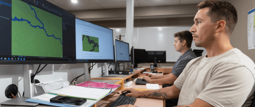
Have you ever hovered your computer mouse over a map image and a name pops up? This is the simplest of GIS applications. If you have good computer skills, a keen eye for detail, and an interest in project management from conceptual design to rollout, the GIS program could be a good fit for you. With many employment opportunities, now is the time to launch your GIS career. Graduates are working in company offices and remotely.
GIS is a one-year certificate program offered full time at Saskatchewan Polytechnic Prince Albert Campus.
You’ll learn the concepts, practice the applications, and build expertise in using GIS software to analyze and map data. In this hands-on approach to applying GIS technology, you will learn about:
- Drone, or Uncrewed Aerial Vehicle (UAV) data acquisition, processing, and interpretation
- Global Positioning Systems (GPS)
- GIS process automation
- GIS analysis and spatial mapping
- Database and worksheet design
- Web mapping and web cartography
- Remote sensing and image analysis
Learn by doing
Serve in the Canadian Armed Forces
Career and salary information
Your career
Saskatchewan Polytechnic has an excellent track record when it comes to getting grads into jobs: 80% of GIS grads are working in their field within six months of graduation. They work as GIS mapping technicians, GIS specialists, mapping cartographers, GPS operators, data analysts or remote sensing analysts. With your specialized training in applying GIS to resource management, you can explore job opportunities with a wide variety of potential employers, including natural resource-based industries, First Nations industries, consulting firms, environmental agencies, government departments and municipal agencies.
A GIS certificate from Sask Polytech can also help you move your career forward. Read more about how a few graduates enhanced their education and careers by taking the GIS program.
Potential careers
| Sample job title | NOC classification |
|---|---|
| Geographic information system technologist | Technical occupations in geomatics and meteorology (22214) |
| Geographic information system technician | Technical occupations in geomatics and meteorology (22214) |
| Geographic information system analyst | Technical occupations in geomatics and meteorology (22214) |
| Geomatics technologist - cartography | Technical occupations in geomatics and meteorology (22214) |
Part-time delivery
Admissions
Admission requirements
- Grade 12
- Minimum 65% grade in a 30-level English Language Arts
- Minimum 60% in Workplace and Apprenticeship Math 30 or 60% in Foundations of Math 30 or 60% in Pre-Calculus 30*
- English Language Requirement
Note
- Computer literacy is recommended.
*Previous Saskatchewan mathematics requirement also accepted:
- Minimum combined average of 60% in Math A30 and B30
Alternative admission
Applicants who do not possess the academic qualifications for a program may be admitted if evidence of probable success can be established through an alternative admission assessment. Applicants are automatically considered for alternative admission. However, some specific admission requirements may still need to be met.
ACCUPLACER©
Refer to the ACCUPLACER© cut scores for this program below, and review additional details concerning Alternative Admission using Accuplacer.
- 250 Arithmetic
- 254 Quantitative Reasoning, Algebra, and Statistics
- 253 Reading
- 247 Writing
Post-secondary
Some programs allow applicants to meet the admission grade level requirement using 15 approved post-secondary credits. Review additional information.
Admission method
First Qualified/First Admitted
The First Qualified/First Admitted (FQFA) process is used for the majority of Saskatchewan Polytechnic programs. When we determine that you meet the program's admission requirements, you will be offered admission based on the date you fully qualify for the program. The earlier you provide the appropriate documents and information that qualify you for admission to the next intake, the earlier you might begin your studies.
Applications for all FQFA programs open September 1 each year.
Sponsored programs or programs targeted to specific groups do not accept applications year round or maintain an application pool.
See Admission Processes for more information about this method of admission.
Tuition and fees
Estimates are based on current rates and are subject to change. Amounts for a program may vary by campus. Totals shown here include all mandatory fees as well as approximate cost for books and supplies. Visit the Tuition and Fees web page for a complete breakdown of tuition and fees for this program.
2026-27 academic year
$8,670
$8,230 (online)
International students
View tuition rates for international students.
Courses
The PROJ-117 course is an applied research project. Students work with external clients which is usually done remotely.
Get credit for what you know
Prior Learning Assessment and Recognition
Saskatchewan Polytechnic recognizes that adults learn in many different ways. This includes acquiring knowledge and skills through life and work experience or non-formal training.
See link(s) below to get more information about PLAR.
Student awards
Thanks to the generosity of donors and alumni, Saskatchewan Polytechnic gives away more than $2 million in student awards during the academic year.
Saskatchewan Polytechnic offers student awards for every certificate and diploma program at every campus. Not all student awards are based on marks - some are based on financial need or things like community or volunteer involvement.
Accreditation
Saskatchewan Association of Geomatics Technologists; GIS Certification Institution
Related programs
Integrated Resource Management
Resource and Environmental Law