
Saskatchewan Polytechnic has been working closely with Cowessess First Nation and Chief Cadmus Delorme on a joint initiative, the Remote Sensing of Residential School Cemeteries applied research project. In addition to the scientific findings, this project will help Cowessess First Nation narrate their story.
Chief Delorme has said, “Every community has its stories about the negative impacts that took place at Canada's residential schools.” This includes Marieval Indian Residential School, which operated between 1899 and 1997 in the area where Cowessess First Nation is now located.
The Marieval Indian Residential School and its associated church managed the cemetery, which was used as a burial place for students who died while attending the residential school. The cemetery was bulldozed in the 1960s to remove the existing grave markers. Those gravesites are now unmarked and unidentified. Cowessess First Nation took control of the cemetery in the 1970s and it is now part of the area that the First Nation uses as their community cemetery.
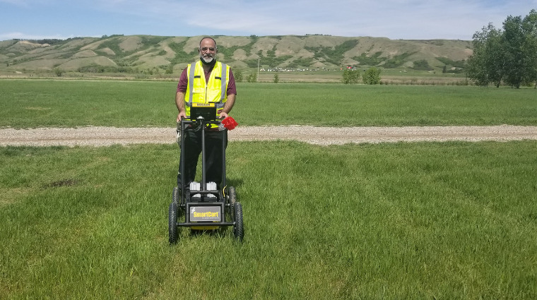
In partnership with Cowessess First Nation, Sask Polytech used remote sensing technologies, specifically unmanned aerial vehicles (UAVs) with imaging sensors, together with traditional ground penetrating radar (GPR) to locate unidentified and unmarked grave sites. The research conducted during this project will help refine the use of remote sensing technologies to support GPR scanning and to establish best practices to improve the efficiency and effectiveness of such work.
The Sask Polytech applied research team started scanning the cemetery area identified by Cowessess First Nation using GPR in early June 2021. GPR scanning is a labour intensive and time-consuming process that involves walking the GPR unit over a large area in an equally spaced grid pattern. The process is slow and looks similar to mowing an invisible lawn.
The team identified numerous anomalies that indicate possible locations of unmarked graves. The GPS coordinates of these ground anomalies were collected using advanced surveying techniques. This information was used to create digital maps of the area using GIS technology. Geostatistical techniques will be used to establish spatial distribution of these ground anomalies and possible gravesites.
In the near future, the researchers will conduct UAV flights over the same area which was scanned by GPR. Those flights will use a variety of imaging payloads in an attempt to establish a relationship between aerial observations and results obtained from the GPR scans. From there, the intent is to survey other parts of Cowessess First Nation to determine if there are additional potential grave locations outside of the known cemetery area.
“Cowessess First Nation is grateful for the work that technical lead Dr. Abdul Raouf and Sask Polytech has been doing with us. To begin this project, Dr. Raouf presented a Cowessess First Nation elder with tobacco to ask for blessing in what he and the team was about to do,” says Chief Delorme. “Since June, the findings have been tough to discuss for many and healing as well, knowing we will honour the unmarked graves. Dr. Raouf and the team has shown the upmost willingness to get this to the end goal while respecting Cowessess First Nation's custom approach.”
The Remote Sensing of Residential School Cemeteries project will help to determine the spatial extent of cemeteries and the number of graves within them. This project is ongoing, and the final number of possible gravesites/ground anomalies will be released after the completion of the project. Planning started two years ago, but work was deferred through the COVID-19 pandemic.
“Through our applied research expertise, Sask Polytech is honoured to support the Cowessess First Nation in this extremely significant search,” says Dr. Larry Rosia, Sask Polytech president and CEO. “It is our hope that our research findings serve to establish a new set of best practices, allowing researchers to collect data in the most efficient manner to better support our Indigenous partners and communities in this critical work.”
Sask Polytech’s applied research team is honoured and thankful to the Cowessess First Nation community and Chief Cadmus Delorme for their continuous support and help. Ultimately, the applied research team hopes this project can contribute to reconciliation efforts. The research team is led by Dr. Abdul Raouf and includes Carlos Lara and Dr. Herve Lahamy. All are researchers from the Geomatics and Surveying Engineering Technology program located at Sask Polytech’s Moose Jaw Campus.
This project is funded by the NSERC’s College and Community Innovation Program, through the College and Community Social Innovation Fund. The work being undertaken started in June 2021. The process to establish a relationship between the images captured by UAV, satellite and GPR will continue over the next year.
This is the first remote sensing of a residential school cemetery that Sask Polytech has been involved in. The applied research program has used GPR, UAV-mounted imaging and satellite technology previously for forestry, agriculture and conservation related projects.
In 2018, Cowessess First Nation and Sask Polytech Geomatics and Surveying Engineering Technology faculty members created a mapping procedure to help 911 responders locate Cowessess First Nation emergencies more quickly. This was a successful partnership, lead by CJ Pelletier, Geomatics and Surveying Engineering Technology program head, that grew to support the establishment of the Remote Sensing of Residential School Cemeteries project.
The Cowessess First Nation is located on Treaty 4 Territory in the Qu'Appelle Valley 20 kilometers north of Broadview, SK.
Published July 2021